


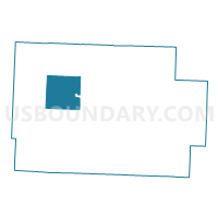
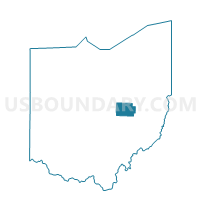
PRECINCT JEFFERSON, Coshocton County, Ohio
About
Outline

Summary
| Unique Area Identifier | 643810 |
| Name | PRECINCT JEFFERSON |
| County | Coshocton County |
| State | Ohio |
| Area (square miles) | 25.90 |
| Land Area (square miles) | 25.89 |
| Water Area (square miles) | 0.01 |
| % of Land Area | 99.97 |
| % of Water Area | 0.03 |
| Latitude of the Internal Point | 40.34081680 |
| Longtitude of the Internal Point | -82.03960930 |
Maps

Graphs
Select a template below for downloading or customizing gragh for PRECINCT JEFFERSON, Coshocton County, Ohio


Neighbors
Neighoring Voting District (by Name) Neighboring Voting District on the Map
- PRECINCT BEDFORD, Coshocton County, OH
- PRECINCT BETHLEHEM, Coshocton County, OH
- PRECINCT CLARK, Coshocton County, OH
- PRECINCT JACKSON NORTH, Coshocton County, OH
- PRECINCT MONROE, Coshocton County, OH
- PRECINCT NEW CASTLE, Coshocton County, OH
- PRECINCT PERRY, Coshocton County, OH
- PRECINCT TIVERTON, Coshocton County, OH
- PRECINCT WARSAW, Coshocton County, OH
Top 10 Neighboring County Subdivision (by Population) Neighboring County Subdivision on the Map
- Jackson township, Coshocton County, OH (1,947)
- Jefferson township, Coshocton County, OH (1,500)
- Bethlehem township, Coshocton County, OH (1,123)
- Perry township, Coshocton County, OH (711)
- Clark township, Coshocton County, OH (586)
- Bedford township, Coshocton County, OH (564)
- Monroe township, Coshocton County, OH (525)
- Newcastle township, Coshocton County, OH (475)
- Tiverton township, Coshocton County, OH (449)